Traveling more than an hour to go fly fishing often requires some planning. Weather and water levels are the two most important variables to understand before heading out. Everyone has their favorite weather apps, but this year more than ever, having a good understanding of water levels has been non-negotiable.
All water level data originates from the United States Geological Survey (USGS) Surface-Water Data, which monitors over 13,000 stream gauges across the U.S. and more than 350 in Pennsylvania. The USGS has been transitioning to a new online interface over the past five-plus years. The updated look and feel have left some old features behind while adding new ones. I hate it.
So, I’ve been on the hunt for a desktop and mobile app that delivers USGS backend data through a clean, easy-to-use interface. Blue Liner Flows offers a solid solution for iPhone, iPad and Mac users, with apps built for both platforms. Most importantly, favorites and preferences sync across devices. There’s a free version, but I’ll be reviewing the $6.99 annual paid version.
Key features include: favorites, state selection, map view, latest data overview, discharge in CFS, discharge in feet, average annual discharge, various time views, weather forecasts, alerts, temperatures (station-dependent), turbidity (station-dependent), and other data specific to each gauge.
I found the app very easy to set up on my Mac. Once configured, all my favorites and alerts synced automatically to my iPhone. You don’t need both devices—an iPhone alone works just fine. I especially liked navigating between the state, favorites, and map views. It’s fast and intuitive. Most views display the key information I’m looking for, including directional arrows indicating whether water levels are rising or falling.
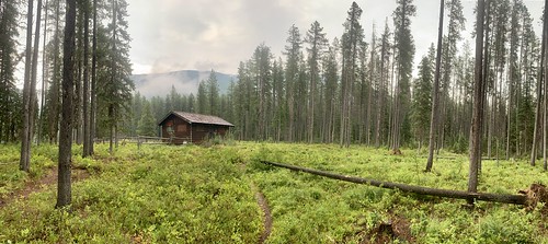
I was selected as an Artist in Residence for The Bob Marshall Wilderness Area, which gave me the opportunity to spend two weeks deep in the backcountry of The Bob Marshall Wilderness (technically, I was in the Great Bear Wilderness, but it’s part of The Bob) in Montana to write and explore. Mules packed all my gear into an old Forest Service cabin that had propane lights and a stove. No running water, no electricity, and an abundance of mice. The cabin sat on a high ledge above the river which gave me access to plenty of fishing for Westslope Cutthroat Trout and Whitefish, a number of trails for hiking, and a great view to watch while I spent each first and last light writing.
The fishing was incredible. I fished four flies the entire two weeks: a purple foam hopper, a caddis, a purple haze, and a streamer (occasionally, when it got really windy). They seemed to be keyed in on anything purple. At first, I had trouble getting my timing down — the river was crystal clear and I would watch these cutthroats come up for my fly from ten feet away and get excited and set the hook way too early. I switched over to my McFarland 7’6” 4 wt Spruce Creek fiberglass rod which forced me to slow down. I ended up catching most of the fish on that (including some pretty big ones). It was a blast. Simple. Easy. Consistent.
I also hiked up a few mountains while I was there (which I go into more detail on in my blog post). It was a pretty amazing experience, but it wasn’t without its difficulties. Hiking and flyfishing in grizzly country (The Bob has the highest density of grizzlies in the lower 48) was a challenge and forced me to be hyper attentive (I did meet a grizzly, but I’ll save that story for the blog…). I also knew that if I slipped or tripped or fell while fishing or hiking...